
Using eyes in the sky to locate seals in a rapidly changing Arctic
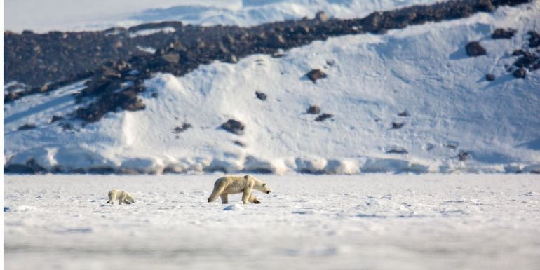
NIOZ Royal Netherlands Institute for Sea ResearchResearchers from the Royal Netherlands Institute for Sea research, Wageningen University & Research and Aeria visited the waters around Svalbard, Norway, to make high resolution drone images of different species of seals. After comparing these drone images with satellite images, algorithms can be developed to automate the detection of seals in satellite images. To the researchers’ surprise, these satellite images not only revealed the location of breathing holes, but also tracks of polar bears. These satellite images are a valuable conservation tool for Arctic marine mammals, who are highly dependent on sea ice, which is rapidly diminishing due to global warming.
This summer, researchers managed to collect stunning drone images of both ringed seals and walruses. In one fjord, the St. Jonsfjorden, twelve ringed seals were found spread out throughout the fjord, resting on the ice. However, approaching and identifying these individuals is very challenging. Since ringed seals are hunted by polar bears, any mammal – either walking on four or two legs – will be avoided at all costs.
“By using a drone, we managed to make high resolution images of ringed seals on the ice resting next to their breathing holes. Based on these images, the species can be easily identified”, says Geert Aarts, project leader of the Arctic Seal project. For this specific region, the researchers also obtained satellite images. Since the ice is landlocked and doesn’t move, the locations of breathing holes are practically fixed. Therefore, the researchers could match the individual seals located on the drone image directly to the breathing holes visible in the satellite images. “Although we were aware of the potential of such satellite images for observing mammals from space, we were struck when we noticed white lines across the ice shield connecting the breathing holes. In this remote environment, this can only mean one thing: polar bear tracks.”
Machine learning to count artic mammals
The resolution of satellite images has improved considerably in the last decade. These satellites, orbiting the earth at a height of more than 600 kilometres, can photograph any place on the earth’s surface at a resolution of 30 x 30 centimetres. By also downscaling the high-quality drone images to 30 x 30 centimetre resolution, the researchers can create a photo which mimics that of the satellite images taken from space. “Eventually, these images can then be fed to a machine learning algorithm and used to train a neural network”, says Jeroen Hoekendijk, PhD candidate, who was part of the research team and works together with EPFL to further develop these techniques. By applying this trained network to satellite images, researchers hope to be able to automatically detect seals in these remote and hostile regions.
Seal species use the polar ice differently
Seals and walruses are especially abundant in the Arctic regions. Each of these pinniped species has its own unique characteristics and relationship with the sea ice. Ringed seals for example, make breathing holes in sea ice fastened to the coastline. These breathing tubes can be several meters long and connect the sea water underneath the ice with the air above. By using their claws on their front flippers, they prevent these breathing holes from freezing. During the long and dark winter months these breathing holes are covered by snow. These snow dens offer their pups some protection from the harsh conditions outside.
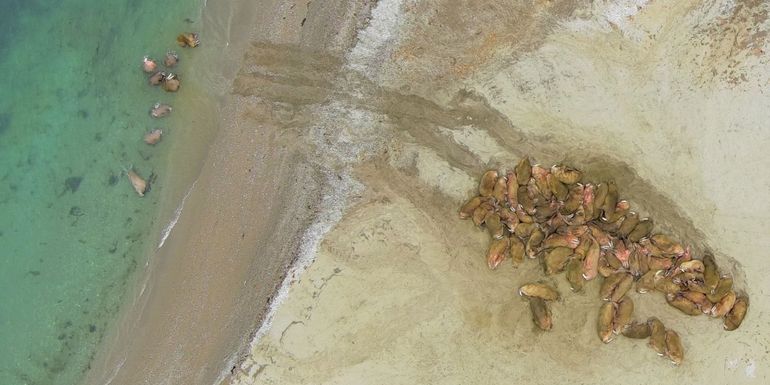
In contrast, harp seals rest and give birth on the drifting pack ice. This pack ice covers most of the north pole region in winter, connecting all landmasses in the polar region, but is reduced in size during the summer months. In contrast to fast ice, the pack ice drifts and can move several kilometers per day. Sudden changes in current and wind direction can quickly cause a breakdown of the harp seal’s birthing platform. Walruses also make use of the pack ice, but individuals can also be found resting on land. Also, during the Svalbard research expedition this summer, the researchers managed to collect drone images from Walruses which may help others to develop similar machine learning techniques for this species.
Rapidly changing home
Ultimately, the researchers hope to use these remote sensing techniques to locate seals in the Arctic. Due to climate change, their home is rapidly changing. This is particularly the case for the North Barents Sea and the islands of Svalbard and Franz Josef Land. This region is the fastest warming place on Earth, with average temperatures rising 2.7 degrees Celcius per decade, and even 4 degrees Celcius per decade during the autumn months. Therefore, knowing which habitats seals rely on is urgently needed to study the effect of climate change and conserve these species.
Text: Koninklijk Nederlands Instituut voor Onderzoek der Zee (NIOZ)
Photo's: Eelke Folmer, Aeria/NIOZ/WUR; Jeroen Hoekendijk, NIOZ