
Modernizing mangrove monitoring in the Dutch Caribbean
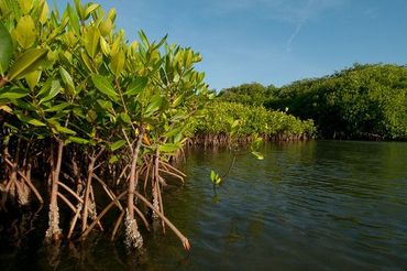
Dutch Caribbean Nature Alliance (DCNA)Mangrove ecosystems, crucial for ecological balance and human well-being, are facing severe degradation globally. This issue is particularly true within the Caribbean, where mangroves have declined by 7.9 percent between 1996 and 2020. In this context, monitoring and managing these ecosystems has become imperative, yet challenges persist due to accessibility and limited resources availability. A recent study conducted in Lac Bay, Bonaire, presents a groundbreaking solution leveraging Sentinel-2 satellites.
Mapping mangroves
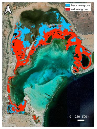
This recent study evaluated the use of Sentinel-2 satellite imagery to map the extent and species composition of mangrove forests in Lac Bay. Results showed that Sentinel-2 data are a valuable tool, providing accurate maps with a mean overall accuracy of over 95 percent. Using five Sentinel-2 images, the extent of mangrove forests in Lac Bay was estimated to be approximately 222.3 hectares, comprising mainly of red mangroves (Rhizophora mangle) and black mangroves (Avicennia germinans).
Remote sensing indicators
This research also attempted to assess the ecological condition of the mangrove forests through biophysical variables, namely Effective Leaf Area Index (used to assess the density of vegetation) and Net Primary Productivity (NPP, how much energy plants are storing as biomass. Despite the success in mapping, there were challenges in validating estimates, stressing the need for further refinement. Estimating NPP based on remote sensing showed promise but needs to be further developed to fully replace traditional monitoring methods.
Implications for conservation and management
Using satellites imagery has proven to be a game-changer for monitoring mangrove ecosystems. The study in Lac Bay showcases the potential of this technology to overcome challenges in mapping, assess ecological conditions, and support conservation efforts. As mangroves have recently gained attention for their value as a powerful nature based solution, it will become increasingly important to monitor and preserve these vital coastal ecosystems for the future.
Tekst: DCNA
Beeld: Hans Smulders (leadfoto: mangroven bij Lac Bay); Henkjan Kievit; DCNA